The NIVEL inclination sensor is designed for use with the Leica Geosystems Laser Tracker series. The NIVEL mounts on the top of the sensor unit or on the top of the Overview Camera / T-CAM to establish the parameters for the Orientation to Gravity. It then mounts on a bracket to monitor the stability of the Laser Tracker.
For detailed information on the configuration and use of the Nivel sensor, see the "Nivel 230 Hardware Guide" provided with your Nivel sensor. Leveling to gravity is not required, but it does improve the Leica Tracker measurement results.
To level to gravity and monitor the Leica Tracker:
Mount the Nivel sensor to the top of the Leica Tracker or the top of the T-Cam (if it is already mounted to the tracker). See the "Nivel 230 Hardware Guide".
Connect the LEMO cable to the Nivel.
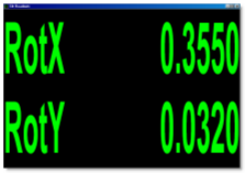
Select the Tracker | Nivel | Start Tilt Readout menu item to display the Tilt Readouts window. The Tilt Readouts window helps by reading the Nivel measurement three times per second. You can maximize the values on the whole screen if you need to.

Using the Tilt Readouts window to roughly level the tracker
Use the Tilt Readouts window to level the Leica Tracker base and the Nivel according to the steps in the "Nivel 230 Hardware Guide".
When the tracker is roughly leveled and brought into an acceptable working range, select the Tracker | Nivel | Start Orient to Gravity Process menu item. The laser tracker then performs Nivel measurements in all four Quadrants of the laser tracker and creates a generic plane feature and a leveled sensor coordinate system based on this plane.
Any additional new alignment commands can use the gravity information if required.
Once you complete the procedure, PC-DMIS prompts you to move the Nivel to the monitoring position.

Mount the Nivel to the monitoring position according to the steps in the "Nivel 230 Hardware Guide".
Select the Tracker | Nivel | Start Monitoring menu item. This begins to monitor the status of the Leica Tracker. The Level To Gravity tab of the Machine Options dialog box provides information about the leveled status. Every 60 seconds, a reference Nivel measurement is made and compared with the original orientation.
The monitoring process makes sure that nobody moves or hits the tracker. You can start it explicitly if no Gravity plane is needed. In this case, you should monitor only the stability of the system.