The information from a CSV file can only be imported.
Select File | Import | CSV to import information from a CSV file.
Each row in the CSV file represents a feature and a feature command that PC-DMIS creates during the import. If tolerance values are specified, a location dimension command is also added.
The first row of the CSV file contains the format designators. This designator row indicates the data for each column. There are predefined column headers. Columns that do not include a format designator or that have an unrecognized column header are ignored. Columns can be in any order. If the "Type" column is missing or if there is no feature type specified for a row of data, PC-DMIS treats this row of information as a "Point" feature.
If a row has only an asterisk in column 1 of the first column with no other information in the row, this signals that the next row is a format designator row. This lets you switch formats inside a single CSV file.
File Format...
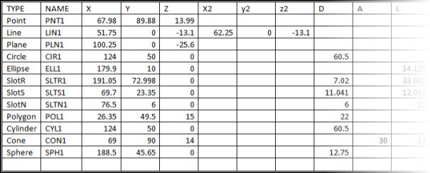
A CSV file is a Comma Separated Values file created by many software packages, including Microsoft Excel. Here is an example of an Excel table used to create a CSV file:
Partial spreadsheet table example 1 used to create a CSV file - continued below
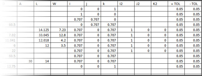
Continuation of the spreadsheet table example from above used to create a CSV file
Download the above CSV example file here: CSV_Example_File.csv
Another example of a spreadsheet table used to create a CSV file is shown below:
| TYPE | NAME | X | Y | Z | +TOL | -TOL |
| Point | X48a001 | 68 | 90 | 14 | 0.05 | 0.05 |
| Point | X48a002 | 74 | 85 | 12 | 0.05 | |
| Point | X48a006 | 76 | 84 | 11 | ||
| Point | X48a011 | 79 | 83.5 | 10.75 | 0.035 | 0.035 |
| Point | X48a021 | 85 | 83.25 | 10.67 | 0.035 | 0.035 |
| Point | X48a022 | 88 | 2.375 | 10.5 | 0.035 | 0.035 |
| Point | X48a029 | 97 | 82.125 | 10.375 | 0.05 | 0.05 |
Spreadsheet table example 2 used to create a CSV file
The first row (TYPE, NAME, X, Y, Z, +TOL, -TOL) is the format designator row.
Note that in the second example, row two is a point feature, specifying both +TOL and -TOL. Both a point feature command and a location dimension command are added based on this row of information.
Neither +TOL nor -TOL are specified in the point feature in row four. Only a feature command is added. A location dimension command is not added.
Format Designators
The very first line (or row if viewed in Excel) in a CSV, is the format designator line. It determines what type of data is expected in the subsequent lines. The following is a list of valid format designators allowed when a CSV file is imported.
TYPE – This is the feature type. The legal entries for this column are: Point, Line, Plane, Circle, Ellipse, SlotR, SlotS, SlotN, Polygon, Cylinder, Cone and Sphere.
NAME – Feature name
X : Feature’s nominal X-value
Y : Feature’s nominal Y-value
Z : Feature’s nominal Z-value
X2 : Feature’s second nominal X-value
Y2 : Feature’s second nominal Y-value
Z2 : Feature’s second nominal Z-value
D : Feature’s nominal Diameter
A : Feature’s nominal Angle in degrees
L : Feature’s nominal Length
W : Feature’s nominal Width
i : Feature’s nominal i-vector
j : Feature’s nominal j-vector
k : Feature’s nominal k-vector
i2 : Feature’s second nominal i-vector
j2 : Feature’s second nominal j-vector
k2 : Feature’s second nominal k-vector
+TOL : Feature’s plus TOLerance
-TOL : Feature’s minus TOLerance
Asterisk (*) Character for Multiple Format Designators
An asterisk character (*) in the very first position of a comma delimited row indicates that this is the end of the data for the current format designator. It also indicates that the next row is a new format designator row. This lets you have features of multiple types in the CSV file with simpler format designator rows:
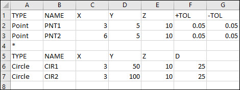
The * in row 4 tells PC-DMIS to use the new format designator row in row 5 for the two circle features
File Import Sequence
The following describes the sequence of events that occur when you import a CSV file:
Each row of data is read into PC-DMIS from the CSV file.
The information is matched with the previously defined column headers to determine the meaning of each item of information.
Based on the feature type, PC-DMIS uses the information to create a feature command.
If one or both tolerance values are specified, PC-DMIS adds a location dimension command.